FEMA.gov vs. InterFlood flood map — who will be the victor?
Written by a la mode on August 15, 2016
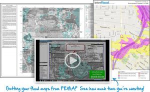
If you’re using FEMA to get flood maps for your appraisal — you’re wasting time. What’s shocking is how long it takes to get a map from FEMA.gov versus adding an InterFlood map straight out of the TOTAL system. Watch the video below to see exactly how using an InterFlood map from TOTAL is the quicker and more convenient solution.
As you can see, adding a map to your report from the FEMA website can take a lot of time that you could spend on other, more important tasks. It took almost six minutes for the entire map to download from FEMA website due to its size. And by the time we added it to the bottom of our forms, there were still steps left in the process — like adding a tag to show the location of the subject property, in addition to adjusting the resolution and quality settings.
With InterFlood, all it takes is one click, "Add Map" to pull up our map options and choose our FEMA flood map from InterFlood. Then, InterFlood automatically uploaded a full-color, automatically-sized flood map straight into the report. Pair that with all your location and comps details, and you're done in about a minute.
Five minutes vs. one minute? Who's the victor now? Stop wasting your valuable time.
{{cta('77dd6228-6250-4093-a233-135568a59980','justifycenter')}}
Start shaving minutes off every report with InterFlood. Click here to start using InterFlood maps now, or give us a call at 1-800-ALAMODE.
Use promo code FLOOD0816 to save $50 on 200 Interflood maps now through the end of August.